Earthquake on More Mesa?
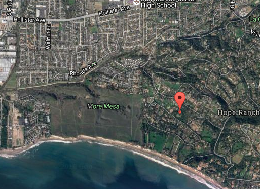
On the very first day of last month, at 8:42 in the morning, a magnitude 2.7, earthquake was reported for the More Mesa area. This event was incorrectly labeled in the press as the “Goleta Earthquake”. However in fact, the longitude and latitude of the quake epicenter placed it near a residence in Hope Ranch, about 1/3 mile due east of the edge of More Mesa (See aerial photo below.)
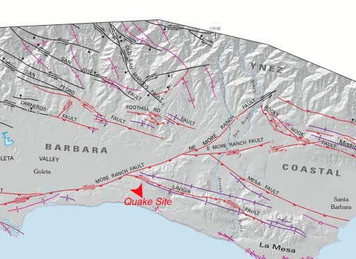
This low magnitude quake was not an unusual occurrence because our area, like most of California, is riddled with earthquake faults … and tremors are very frequent. For example, there have been 97 events of magnitude 1.5 or greater in Santa Barbara during the last year. The geologic map below shows various faults in the immediate area of More Mesa, with either black or red lines depending on the geologic deposits involved. Prominent among all the small faults shown, and at the north-eastern section of More Mesa, is the intersection of two larger faults, the More Ranch Fault and the Lavigia Fault.
To learn more about the geology of More Mesa, go to our 2014 Symposium videos and click on any of the titles. All Symposium videos will then appear on Vimeo. Geology is discussed in the talk titled “Ecology of More Mesa.”
We are indebted to the U.S. Geological Survey for providing the new and updated map geologic map of the Santa Barbara area, a map formulated with a major contribution from our own Dr. Edward Keller of UCSB.