Living With the Lockdown – Treasure Hunt #14

WHAT HAPPENS WHEN HISTORY FALLS INTO THE SEA?

mesa edgeIt All Starts with a Tiny Cactus

This Treasure Hunt is not about a gift from Mother Nature, but a story about a telephone line. It begins a hundred years ago with, surprisingly enough, a gift from Mother Nature, a tiny Prickly Pear Cactus. This little plant was on the property of the eldest child (Kate Bell) of one of our area’s most famous pioneers; Don Nicholas Den, owner of Rancho dos Pueblos. On Kate’s 76th
birthday, she had a giant celebration, convening the entire clan. And, as part of the celebration, she made a prophetic and wildly accurate prediction. She pointed to a struggling tiny cactus and offered that whomever sunk a well near that cactus would strike oil and become very rich.

As time went by, the tiny cactus prospered and became a large patch*. In 1927, the oily aroma in the area of the large patch launched the beginnings of oil exploration at Ellwood. But after more than a year of frustration, test wells continued to come up dry. However, in mid 1928 with one last gasp effort, cacti
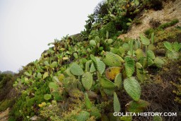
deeper and much closer to the cactus patch, they struck oil and struck it BIG! This one well alone yielded the richest oil yet found in California and ended up producing over a million barrels of high-quality crude. With two separate oil fields, one on land and one in the ocean, the coast at Ellwood quickly became a hot bed of oil activity; including extraction, refining, storage, and transportation. And because the area had so much going on, Kate Bell’s son-in-law feared that the revered cactus patch would be destroyed in the hustle and bustle of the oil field. So, he built an iron fence around the patch to protect it.

*The “patch” can still be seen today east of Haskell’s Beach … on a hillside below the Sandpiper Golf Course.

Enter A “Curious Someone” From Across the Sea

All during the 1930s, there was so much readily available product at Ellwood that tankers from nations all over the world came there to procure oil. The captain of one of these tankers was a highly esteemed Japanese Naval Officer named Kozo Nishino, one who had joined the submarine service in 1923 and captained several oil tankers during the 1930s. As a result of this experience he was very familiar with the Ellwood field and the surrounding coastline. It was on such a mission in the late 1930s, and while his tanker was being loaded, Commander Nishino decided to stroll along our lovely coast and happened upon Kate Bell’s cactus patch – now protected behind the iron fence. He decided that he would like a “cutting” of this strange plant for his garden back in Japan. Unfortunately, he fell into the patch and had to be pulled out by his crew. There were also other things that had to be pulled out … the cactus spines embedded in various parts of his body. While viewing the accident and recovery, American oil workers at the site offered only loud guffaws and embarrassing remarks. Commander Nishino was purported to have vowed revenge*.

*For the full story and wonderful photos of Kate Bell and her cactus see Goleta History.

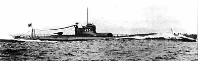
In early 1941, with his career on a definite upward trajectory, Commander Nishino was awarded the newest, biggest “German-like” submarine: one that was the pride of the Japanese fleet. In fall of the year this sub played a part in the “run-up” to Pearl Harbor and was on patrol in the area on that fateful day. As soon as it was acknowledged that the attack was wildly successful, Captain Nishino was ordered to proceed to the west coast of the U.S. on a mission to attack America’s merchant ships.

Commander Nishino's L-17 Submarine was 365 feet long
Commander Nishino’s L-17 Submarine was 365 feet long

Subs in Our Backyard

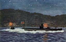
Early Japanese strategy was one of inflicting psychological, rather than physical, damage to the U.S. mainland. The campaign started a scant week after Pearl Harbor, when nine Japanese submarines were deployed to United States shores with orders to eliminate American supply ships and attack nine coastal cities and lighthouses up and down the Pacific coast. Almost all the targets were in California. This was a concerted effort to frighten the American public into thinking a large-scale attack on the mainland was coming next.
As a result, submarines were often spotted from shore in the Santa Barbara area and duly reported to Naval officers stationed here. These officers would then pass the information on to San Diego. On February 16,1942, an employee at the Ellwood oil field reported a sub to the Santa Barbara officer and it was immediately passed on. Three days later the same sub appeared, and the report was again made to the local naval officer who again passed it on to San Diego. This time the return message did not say “Thanks”. It said “Stop sending us these submarine sighting stories – the coast is full of California gray whales. That is what you are seeing, not subs.” The local officer groaned and reported back, “A whale is 20 feet long.* This submarine is 300 feet long.”

*Gray whales are actually more like 35-40 feet long, but they obviously did not have the same great whale books we have today.

Commander Nishino Returns to Ellwood

Captain Nishino, commander of one of the nine subs, was given three potential targets. When he checked them out, the first two were very heavily fortified and armed. Ellwood had not a single gun. So … four days after the “Those are whales, not subs report”, Captain Nishino returned, once again, to the scene of the Cactus Patch incident to lob 16-25, 5 ½ inch shells into the Ellwood coast. He timed the 20-minute shelling just as Americans were settling down around their radios to hear President Roosevelt’s fireside chat to the nation: a broadcast in honor of George Washington’s birthday. No one was killed or hurt during the attack and although the sub fired at a pair of oil storage tanks, they missed. Damage to the entire site was minimal perhaps $500 – $1000*.
Did Captain Nishino come back for revenge? Probably not. The captain was a career military officer, trained to follow orders and he most likely did just that. He did however, bend the truth more than a little bit when he radioed back to Japan saying he’d “left Santa Barbara in flames.”

Japanese propaganda postcard depicting Ellwood shelling

The Ellwood shelling was a rousing success for Japan, because there were massive repercussions throughout America. Panic ensued on both coasts and especially in California. Most shameful was that the attack on Ellwood put an end to any shred of opposition to incarcerating Japanese Americans and ushered in a disgraceful period of illegal and unconstitutional internment. Those of Japanese descent were stripped of all their belongings, property etc. and 48 hours later shipped to camps around the country where they lived for more than 3 years. Of those 120,000 people, 70% were American citizens.

*To learn more about the Ellwood shelling, visit Goleta History.


So What Does This Have To Do With More Mesa?

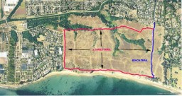
An America at war needed a way to decide if we were being attacked from the air. Because the west coast of the U. S. was viewed as very vulnerable, and as radar systems were in their infancy, aircraft-spotting stations in our area were house graphicbuilt very quickly after Pearl Harbor. Our “line” of spotting stations stretched from Tecolote Canyon to east of Hope Ranch. Stations were staffed by both men and women, all civilian volunteers; among them some of Santa Barbara’s most prominent citizens. These folks worked around the clock in two-hour shifts. Using binoculars and checking against charts of various Japanese planes, spotters reported to “filter” stations using a buried phone line. The filter stations would then forward authenticated reports to an Aircraft Warning Service.

ground observers corpsOur system was probably an early section of the Ground Observers Corps (GOC), a World War II Civil Defense program of the United States Army Air Forces to protect United States territory against air attack. By the beginning of November 1942, there were 1.5 million civilian observers in the GOC, who at 14,000 coastal observation posts performed naked eye and binocular searches to detect German or Japanese aircraft.

About the Telephone Line …

For those of you who read our periodic More Mesa updates, you are probably weary of our persistent nagging about the unstable nature of More Mesa’s cliffs. For those of you who never heard our warning message, here it is …
It is dangerous to go near the cliff edge at any time, and more importantly, never go near the edge after a rain.

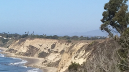
What does this have to do with the telephone line?  It’s all about “what went where” during WW II. During the Ground Observers Corps era, spotter shelters, built on concrete pads, were positioned relatively close to the edge of the cliff. Telephone lines to report sightings were buried much further back from the edge.

More Mesa’s extremely unstable shales erode, on average, about 10 inches a year. (Since I minored in math, I’ll do the numbers.) Ten inches a year since the beginning of WW II equates to the current cliff edge being roughly 65 feet further toward the mountains than it was at the beginning of WW II. The spotter shelters have long disappeared into the Pacific. And, almost all but a very few, and very tiny, sections of the phone lines are also gone. With luck, and extreme care, you might catch a glimpse of a small remnant of this important and bygone system at the cliff edge. In a few years these reminders too will vanish into the deep, marking the end of a tumultuous era that began almost a century ago.

Living with the Lockdown – Treasure Hunt #9

tree-bannerThere are Trees…and Then There are “Trees”
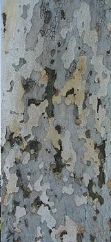
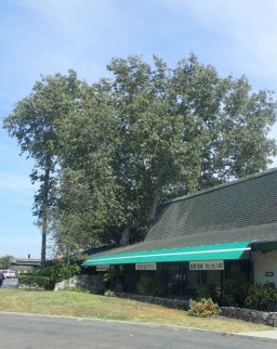
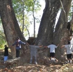
If trees had personalities, I would have to characterize the Tamarisk, of our last Treasure Hunt, as the personification of evil, and today’s Treasure Hunt, as the personification of good. The California Sycamore is beautiful and interesting…in a different way…and during every season of the year. Moreover, it willingly offers sustenance, shelter, shade and safety to critters of all kinds…including us. After learning about our native Sycamore these past days, I can honestly say, I really love this tree!

California Sycamore

The California Sycamore, also known as the Western Sycamore, the California Plane and by several other names, can grow to 100 feet, with a trunk diameter as large as 3 feet. As a young tree, the Sycamore is pyramidal, but as it grows, the trunk generally divides into two or more large trunks which then split into many massive limbs and branches…giving the tree a wondrous rambling, often unsymmetrical, quality that just adds to its beauty.

Really BIG leaves
Really BIG leaves
Bark is beautiful

The five-pointed green leaves of this lovely tree are extremely large, in fact the largest leaves of any native plant in North America. Moreover, when leaves first emerge, they are “fuzzy” on the top side and “very fuzzy” on the bottom side. But unlike many of our native trees, our Sycamore is deciduous, so that when the weather gets colder and the days shorter, these huge leaves put on a “fall show” by turning a striking golden and orangish color. And to provide a color show in winter, the tree boldly displays its bark, which is an attractive patchwork of white, tawny beige, pinkish gray, and pale brown. Indeed, some have described Sycamore bark as looking like a jig-saw puzzle. This colorful and interesting tree is native only to coastal California and the Baja, with its favorite habitats being canyons, floodplains and along streams. And like a few of the native trees of our area, it can live up to 250 years.

It’s Spring and Procreation is in the Air

Male Flowers

The reproductive process for Sycamores starts in very early Spring. Both female and male reproductive organs can be found on the same tree. Male flowers form into small greenish spheres on “strings” that fall to the ground after the pollen of these flowers is released. The hope is that wind will carry

Female Flowers
Female Flowers

pollen from the male flowers to the dense reddish female flowers. These are larger spheres that look like fuzzy gum balls on a string, and are found on the same, or other, Sycamores. Once pollinated, the fruits of this tree are produced in the form of seed balls; golf-ball sized heads of tufted “fruits”, with each fruit containing a single seed. Three to seven of these balls hang on a stalk*, dry out, and then once again, call upon the wind to disperse the seeds for the new generation. To ensure seed dispersal, the individual carriers of the fruits have tufts of hair that act as parachutes…to catch the wind and travel long distances. This is especially helpful when there is a need to rapidly reestablish the species after a flood…smart Sycamore!

*Mature fruits can be seen in the photo at the top of this page.

The Sycamore is the Giving Tree

Sycamores give of themselves for critters all the way from small insects to large mammals like us. Starting with tiny animals, evidence of the use of Sycamore leaves for food may be found when you see holes its leaves. The holes tell you that the Sycamore Tussock Moth

Sycamore Tussock Moth Caterpillar

caterpillar has been lunching. If you find a leaf with holes, you may also note that this caterpillar, and anything else that feeds on the leaves, does not particularly like the thick fuzzy coat on the leaves, or on new stems, so it pushes all that material to the side before dining. In some areas, the Western Tiger Swallowtail Butterfly also lays its eggs on Sycamore leaves…so its caterpillars may feast on them as well. Squirrels and other small rodents and birds, feed on the seeds of the Sycamore, while the bark is a dinner for beavers and fox squirrels. And at the top, these tall trees also provide safe nesting sites for many species of birds.

Sycamores have been giving to humans for a very long time. Native Americans used the inner bark for food and medicinal purposes, the leaves to wrap bread during baking, and branches in house construction. And after Europeans and “Yankees” arrived in California, our Sycamores were so prominent on the Central Coast that they were often used as landmarks. For example, newcomers to the Goleta Valley used sycamores as markers for property limits. Still living, and probably 250 years old, are two famous and gigantic Sycamores known as the Witness Tree and the Sister Witness Tree.

Witness Tree
Witness Tree
Sister Witness Tree
Sister Witness Tree

The Witness Tree still exists in the middle of the Butler Center on Hollister Avenue…surviving a recent fall of one large limb. Its relative, the Sister Witness Tree, just across the street, is credited with being the largest California Sycamore in the United States. These two trees are incredibly important as they were native before Europeans arrived on our coast and being genetically pure…they are extremely rare!

A little later, one tree, which stood on the south end of Milpas Street reportedly was used as a make-shift light house. Residents of Santa Barbara were purported to have hung lanterns in its upper branches to guide offshore sailing ships. However, this explanation for the lanterns probably does not tell the whole story.

shipThe Whole Story

During the period when California was part of the Spanish empire, “the Crown” insisted that all goods to California must come from Spanish merchants. To enforce this unenforceable edict, they levied onerous customs duties on all goods that came from “Yankee” ports…like Boston. Sometimes these duties were as high as 100% of the value of the goods. The law was unenforceable because, beside the fact that there were not enough Spanish ships or goods to meet the demand, there were not enough Spanish officials in the colonies to enforce the law. So…in the late 1790s and early 1800s smuggling became a way of life all up and down the California coast. Since it would be another 70+ years for Stearn’s Wharf to be built, goods destined for Santa Barbara were offloaded onto smaller boats or simply thrown overboard to be retrieved on shore. For smugglers, this clandestine activity went on during the night, when the Customs office was closed. It is therefore, most likely the light in the Sycamore was probably used to indicate to the smugglers where the goods should be put overboard. Yankee goods made life easier for early Californians, and once again, our lovely Sycamore was part of it!

The importance of caring for the tree that gives and gives may not be recognized by everyone. It is, however, recognized by the state of California! In 2006 the California Sycamore was added to the list of trees in our state that are “fully protected”.


Where Are They?

Once you can recognize Sycamores, you will see they can be found all
over Santa Barbara. they grow wild in creeks and canyons and have been

Sycamore on Atascadero Creek
planted in many beautiful and special places all around Santa Barbara…places like the Museum of Natural History, Oak Park and along the Atascadero Creek bike path.They have also been welcomed in private yards, as well as beautifying freeway entrances, exits and parkways. The Sycamore is a tree for all…and we should be very proud of this truly “giving” native being such a big part of our lovely and special little town.

We are indebted to Santa Barbara Beautiful, University of Redlands and Ken Knight for much valuable information on the California Sycamore.

Remember: Six Feet Apart and Stay Safe,
Valerie

Living With the Lockdown – Treasure Hunt #4

A Flower That Blooms for a Single Day … oops a Single Night!

datura
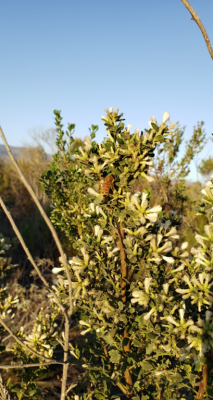
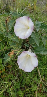
The plant we are featuring in this hunt, commonly known as Datura, and in the Nightshade family, is unusual in many ways. First it has several names, among them: Devil’s Trumpet, Devil’s Weed and Jimson Weed*. And, unlike the Miner’s Lettuce and Willow of previous Treasure Hunts, Datura thrives in dry, temperate and subtropical regions like the American Southwest and Mexico, which is considered the center of its origin. This amazing Datura photo, was taken by Chris Brems on the eastern coastal trail where the paragliders lift off. (Plaque in the ground at this spot reads “Hook In”.) The photo illustrates the fascinating process described in the story below.

A Colorado River Tale

I became aware of this beautiful and interesting plant on a Colorado River trip decades ago. At the end of an exciting day of rapids and magnificent scenery, and while waiting for dinner, a guide pointed to a greenish, unimposing plant in our camp. He urged us to “watch that plant”. Since this guide was quite the joker, we laughed a lot and then told him we would follow orders, and “watch the plant”.
datura-parts
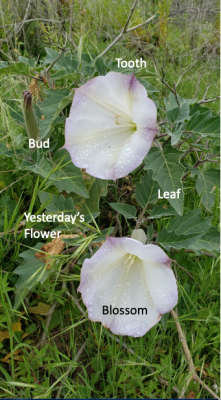
What we saw … as we giggled at the idea of watching a plant … was a furled bud sticking up in the air. It looked like it was bound up with some tiny “hooks”. Then, within a few minutes, the bud began to unfurl, one hook at a time. We were stunned! You could almost hear it going click, click, click as it unfolded into a beautiful trumpet-like flower. It was the Sacred Datura, also called Moonflower, because it blooms late in the afternoon, is pollinized at night, and closes by noon of the following day. While each individual flower lasts only a single night, during any given summer season, one Sacred Datura plant produces dozens of large (6-8 inches), fragrant, whitish (sometimes purple edged) flowers, each with five of the slender hooks that are called “teeth”.

What Happens During the Night?

Sphinx Moth
Sphinx Moth

As you might expect, night-blooming plants must be pollinated by nocturnal visitors, so Datura are pollinated by Sphinx Moths. These evening visitors can be seen feeding on the opened (and short-lived) flowers using a long proboscis that unfurls to reach to the nectar at the base of the bloom. On rare occasions, when Sphinx Moths are not present, pollination can be achieved at dusk and dawn by Honeybees. However, the bees have to work a lot harder, since they don’t have the moth’s long proboscis. As moths and bees gather nectar, they inadvertently assist in pollinating the flowers they visit. This process has something for everyone …

Thorn Apple
Thorn Apple

Mother Nature’s win-win! By noon, about 18 hours after it bloomed, the pollinated flower turns over, closes up and forms a spiny, globe-shaped seed pod called a Thorn Apple. When ripe, the Thorn Apple splits to release seeds and begin the process again.

Datura can be found in several places around More Mesa, on Hope Ranch and on trails and paths all over the Goleta Valley.
*The name “Jimson weed” is said to have originated form the presence of a similar species in Jamestown, Virginia. The name “Jamestown” was corrupted to “Jimson” at some point in time.

History

Datura species have been revered as sacred visionary plants among almost all cultures around the world that have encountered it. Archeological evidence shows that Datura has been in use for at least 3,000 years in the southwestern United States and even longer in other parts of the world. Datura was an integral part of daily life for the Native American Chumash of our region, used both as a sacred and medicinal plant.
Indeed, the Chumash were known to have used this plant more than any other native culture in California. Use of Datura was so ubiquitous that it appears to have worked its way into the famous pictographs of the Chumash. For example, archeologists have interpreted the spiny silhouette around the circles in this pictograph to be Datura fruit; the Thorn Apple. Where is this famous pictograph?  Right here in Santa Barbara at Painted Cave Historic Park!
Rock Paintings of the Chumash ... Campbell Grant
Rock Paintings of the Chumash … Campbell Grant
Epilogue on Pictograph: To ensure that this Treasure Hunt was accurate and responsibly presented, I consulted two of the most eminent Chumash scholars; Dr. Jan Timbrook and Dr. John Johnson, both of the Santa Barbara Museum of Natural History. I asked them to comment on the interpretation of the pictograph. Neither of them had ever heard of the Thorn Apple interpretation. Moral of the story … The Internet is not a scholarly journal. (Go see the pictograph anyway. It’s very cool!)
Also while researching this Treasure Hunt, I discovered that Datura was associated with witches, devils, flying, shape-shifting and transformation. And I also remembered a book that achieved great notoriety in the late 1960s. It was called “The Teachings of Don Juan” and written by an anthropology student named Carlos Casteneda. There was a lot of flying and shape shifting in that book too. Why? Most likely because Datura is a serious hallucinogen and one must take the caution below seriously … very seriously!

Caution!

While Datura is an interesting plant to observe, observing is all one should do with it! All species of Datura and all parts of the plant are highly poisonous!
In her acclaimed recent book, Chumash Ethnobotany, Dr. Jan Timbrook warns
 “Every year people die from ingesting Datura through foolhardiness or misidentification. The dangerous compounds can also be absorbed through the skin.”

Lastly …

Although we are encouraging you to go outside and find these treasures, you do not have to leave anything in exchange. Please carry out all your trash. The onslaught of people onto More Mesa is heartening in that “new to more Mesa” folks will learn to appreciate it, and those who were familiar with More Mesa will cherish it even more. But trash is both unsightly and takes away from its spectacular beauty of More Mesa. Most importantly, please, please pick up after your dogs. The “Poop Fairy” is on Lockdown and cannot clean up after absent-minded dog owners.

It’s All About the Birds and the Bees!

Mother Nature Has Incredible Ability to Bounce Back!

In our Spring Issue we waxed eloquent over the rains that had filled our prolific and very significant vernal pool. And further, those same rains also created an unusually effective ecological chain of events. The rains brought grasses … grasses in great profusion. These grasses then provided an abundance of food for the rodents that are prey for our local birds … the most important of which is our “signature and logo” the White-tailed Kite.

Fledgling Kites Photo Courtesy of Morgan Ball
Fledgling Kites
Photo Courtesy of Morgan Ball

Here’s how the rains inspired the kites. In normal rain years (October 1st of the current year to September 30th of the following year) More Mesa supports two, and sometimes three pairs of adult kites. The nests are conveniently referred to as “East”, “Central” and “West”. Each breeding pair typically has 2-4 chicks per nest, but not all the chicks may survive. “Doing the math” tells us we could have between eight and eighteen kites on and around More Mesa at the end of a breeding season. However the number is typically much closer to eight. During the recent drought, we had several years with no More Mesa chicks reported at all. Last year More Mesa had but a single breeding event that produced two chicks … perhaps the only youngsters in all of the Goleta Valley.

BUT THIS YEAR WAS A BANNER YEAR!  Of the 10 breeding events in the Goleta Valley, More Mesa had three active nests that fledged at least 10 young and possibly many more. Further, there is some evidence that one or more of the pairs have “double clutched” … that is, they raised yet another set of chicks. In the past we have seen chicks hatched as late as October, so there may even be more to come!

AND EVEN MORE EXCITING … In our extensive web feature about White-tailed Kites, we have described the kite’s  practice of winter communal roosts. We have not observed one of these roosts for many, many years. However, this year, a large communal

Multiple Kites Roosting - September 2019 Photo Courtesy of Barry Rowan
Multiple Kites Roosting – September 2019
Photo Courtesy of Barry Rowan

roost was discovered in the central area of More Mesa. This particular roost is unusual for a couple of reasons. First, roosts typically are a winter phenomenon that occurs, at the time when all, or most of, the chicks are fledged. But this roost was identified in September. Moreover, at one point there were 29 birds observed at the central roost. This is an extremely large number and would indicate that either there were a great many chicks fledged on More Mesa, or there were visiting kites from other areas around the Goleta Valley … or both!  (As of this writing the roost has been abandoned. This is typical behavior, and as yet, an alternate roost has not been identified.)

And What About the Bees?

beesBees, and their almost 300 species of insect buddies, are, as usual, busy nectaring from coyote bushes in flower during the fall and winter seasons on More Mesa.  You can read about this unassuming, but extremely important plant on our web site.

The Past – Taking Another Look at More Mesa’s History

Of late we have departed from the “standard” format we historically used for our periodic e-mail updates. In this issue we are returning to one of our most popular features: that concerning More Mesa’s past. Although we are reprising information shared with you in our very early issues, we are also including new material that has been revealed since we originally published. With that prologue …

The Chumash – The original, local Californians lived on More Mesa as early as 6,000 years ago. However the first mention of these highly sophisticated native people was made by the Cabrillo expedition in 1542. The ship’s journal noted that the area of the Goleta Slough and west More Mesa was the most heavily populated region in all of Alta and Baja California.

First map of the Channel Islands Campbell Grant
First map of the Channel Islands
Campbell Grant

Then in 1602, the first map of the Santa Barbara Channel was drawn by Father Antonio de la Ascencion, diarist of the Viscaino Expedition. In the image shown, we have taken the liberty of translating the handwritten Spanish on the map into English. The “Big Town” was probably Mescalatitlan or Dos Pueblos.

Campbell Grant, in the opening chapter of his book, “The Rock Paintings of the Chumash”, waxes eloquent about the wealth of plants, trees, animal and sea life that were accessible to the Chumash. He says, “It is small wonder that the Chumash chose to live in such a land. It was a fine place to live.” A ramble through More Mesa convinces one that it still is a fine place to live.

A Summer Walk on More Mesa (2018)

Since things have changed quite a bit since our last report, it was time for a Summer Walk on More Mesa. Taking the same route as reported in our previous Update we noted two very heartwarming and special sights.

trails

Baby Kites
Baby Kites

First, the White-tailed Kites that historically nest on the east side of More Mesa have fledged two youngsters this year! This is extremely good news since drought years have produced a very small number of youngsters … for More Mesa and indeed the whole Goleta Valley. You can find all manner of interesting information on the importance of More Mesa’s kites on pages 29-33 of our More Mesa Handbook.

Lorquins Admiral
Lorquin’s Admiral – one of 17 species on More Mesa.

With summer comes butterflies when More Mesa hosts up to 17 different species of these beautiful creatures. In addition to the Buckeyes reported in our last issue summer brings the lovely, and large, Anise Swallowtails that lay their eggs on our ubiquitous fennel. For a detailed discussion of the Swallowtail and its appearance on More Mesa see our late summer issue for 2017.

If you have taken the walk above, and parked on Puente Drive you will have noticed how many cars have been there … almost every day this summer. The extreme heat has brought hundreds of visitors to More Mesa and the beach below.  Which brings us to the story below …

A Legend From the Past

The intense hot spell we have been experiencing lately, with its record breaking temperatures, seemed to echo a story I had come across while researching for an article on More Mesa’s asphalt mine in a previous issue. According to our colorful, always interesting, and “go-to” reference Goleta, the Good Land (by Walker A. Tompkins), a scorching one-day heat wave occurred in the Goleta Valley on June 17, 1859. Further, it was the first and only simoon ever recorded in North America. Never having heard the word “simoon”, I looked it up. What’s a simoon anyway? It’s a strong, dry, dust-laden local wind that is caused by intensive ground heating under a cloudless sky. The word simoon is Arabic and describes winds that occur in the Sahara, Israel, Jordan, Syria, and the deserts of Arabian Peninsula.

thermometer
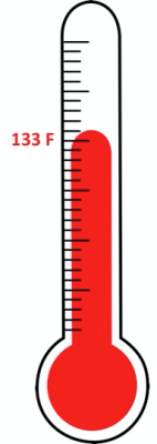
So what did happen in June 1859? According to Tompkins, it was about 80 F by noon on that fateful day… a little high for our lovely Goleta Valley … known for its moderate temperatures. Then, about 1 PM according to Tompkins, a ‘blast of superheated air’ came from the direction of Santa Ynez Peak and hit the Goleta Valley, alarming the residents and sending them scurrying for cover inside thick-walled buildings. Tompkins wrote that by 2 PM the temperature had reached an incredible 133 F, with the northwest wind bringing ‘great clouds of impalpable dust’. People reportedly took refuge in several places including behind the 3-foot-thick walls of the Daniel Hill adobe. Calves, rabbits, and cattle died on their feet according to a “government report”, and fruit fell from trees to the ground, scorched on the windward side. Birds fell dead from the sky and others flew into wells in search of cooler air and drowned. About 5 PM the searing, hot wind died down, the report said, the thermometer ‘cooled off’ to 122 F.

Supposedly the temperature in the Goleta Valley hit 133 F, and went into the record books as the highest temperature for all of the U.S. … remaining a record for 54 years, when it was barely surpassed by a 134 F reading in Death Valley.

I thought this was a thrilling story and all More Mesa supporters would love it!

But …
However, while finishing up my research on the word “simoon” I ran across an article by Bill Norrington that was posted on the UCSB Geography Department website.  My hopes for relating this exciting (and “hot”) story about La Rancho Goleta … the ranch that included More Mesa … were trampled, if not dashed!
Unhappily, the story appears to exist only in the Tompkins book, with no scientific evidence whatsoever for the event appearing in, or being corroborated by, any other record, “government” or otherwise. Norrington goes on to chronicle Thompkins’ life as a writer of western novels (fiction), a reporter, a radio personality, and a staff writer for the Santa Barbara Newspress.
In addition, when Professor Joel Michaelsen of the Geography Department was asked about the event he commented: “I have never found any outside source to validate Tompkins’ story, and I am highly skeptical of its veracity. I don’t doubt that strong hot, dry down-slope winds could kick up lots of dust and produce very high temperatures – but in the 110 F- 115 F range at most. The 133 F just isn’t physically reasonable, as it would require the creation of an extremely hot air mass somewhere to the northeast. Our recent weather was a very good strong example of the sort of conditions that would produce such a heat wave, and our temperatures topped out at least 20 degrees below Tompkins’ figure. Stronger winds could have increased the heating a bit, but not nearly that much.”
If you add Professor Michaelsen’s  factual and scientific skepticism to the fact that Thompkins was a known spinner of tales … the 133 F probably !never happened.  Science triumphs!
We are deeply indebted to Bill Norrington and the Geography Department at UCSB for allowing us to share their fascinating story with you.

Stay Cool and Enjoy More Mesa!