History of More Mesa
More Mesa has a long and layered history shaped by the land’s rich natural resources and changing patterns of use over thousands of years.
Early Inhabitants
Archaeological evidence shows that the Goleta Valley has supported Indigenous communities for at least 6,000 years. The nearby Goleta Slough—just a mile west of More Mesa—was home to one of the largest settlements in Alta and Baja California during the 1500s. More Mesa itself was used mainly for gathering and fishing rather than permanent habitation, as indicated by the limited artifacts found on-site, including stone tools and shell fragments.
Ranching Era
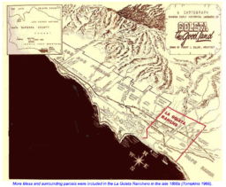
After the arrival of Spanish missionaries in the late 1700s and the resulting decline in Chumash populations, More Mesa was primarily used for cattle grazing. In 1846, the Mexican government granted the land to Daniel A. Hill, who later sold roughly 1,000 acres—including More Mesa—to T. Wallace More in 1864. More established the Goleta Ranch, which included orchards, pastureland for cattle, and cropland for lima beans, tomatoes, and grains.
The ranch also supported industrial activity. Asphalt was mined near More Mesa and exported along with agricultural goods from a private pier built by More on the west end of the property. A short-lived railroad line was added in 1886 but abandoned by 1899. By the 1920s, Mobil Oil leased portions of the land to explore for oil, ultimately producing only natural gas from wells on the western edge of the mesa. Through the first half of the 20th century, grazing and limited agriculture remained the dominant uses of the land.
Development Proposals and Conservation Efforts
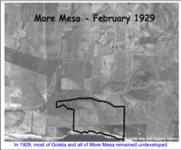
As urban development expanded around Goleta in the mid-20th century, More Mesa became the focus of repeated development proposals. In 1965, a 600-unit “Buena Vida” housing project was proposed but later withdrawn due to public opposition and land acquisition challenges. A few years later, in 1972, the “Tyrolian Village” proposal—also for 600 units—triggered a landmark California Supreme Court decision (Friends of Mammoth v. Board of Supervisors) that required Environmental Impact Reports (EIRs) for major developments.
Following that ruling, Santa Barbara County issued a building moratorium and prepared its first EIR for More Mesa. Although a rezone for development was initially approved, legal disputes halted the project, and in 1973 the County officially denied the rezone request, ending the proposal.
In the late 1970s, approximately 265 acres of More Mesa were purchased by Columbia University, which held the land until 1984, when it was sold to its current owner, Sun Mesa, Inc.
Modern Context
While much of More Mesa itself remains undeveloped, the surrounding landscape has changed significantly. Residential neighborhoods such as South Walnut (built in the 1960s–70s), Vista La Cumbre, and Diamond Crest (late 1980s) now border the mesa, with newer additions like Las Brisas (2005) and Hacienda Vieja (2007). Infill development has also continued in Hope Ranch to the east and More Mesa Shores to the west.
Today, More Mesa stands as one of the last large, undeveloped coastal open spaces in southern Santa Barbara County—a rare reminder of the area’s natural and cultural history, and a focal point for ongoing conservation efforts.